You are invited to attend a series of three presentations this Spring, 2025. It is available only to residents of the Bonita Bay Community Association and their guests.The purpose of these presentations is to give information and encourage you to go.
This is a chance to explore the unique diversity of the SW Florida environment. Topics include our distinct surroundings, plants of special beauty, and our environment compared with other similar but globally distant areas. This presentation is also an opportunity to discuss these varied topics with John Knapp, author of Everglades Ark.
Topics and dates
Location
Community Activities Center: 3451 Bonita Bay Blvd., Suite #100.. Water and coffee included in attendance. No registration needed. Also see the schedule in the Bonita Bay publication Around the Bay
At the door there will be a $5.00 BBCA registration fee and, to help fund the Everglades Ark education effort, a $10.00 donation.
Questions ? Please call the Bonita Bay Community Association, Community activities, 239-390-5550.
Thanks for your interest! See you there. If you wish to be notified of future posts please enter your email and click on subscribe
The native woodlands are foundational for all other Japanese gardens. They have been revered for thousands of years as part of Shinto. They are geologically, ecologically, historically, culturally and economically important. The previous posts in this series have reviewed the cultural insights and history of the Japanese gardens. This is part three of a six part series on Japanese gardens. The purpose of this presentation is to focus on the value and management of the forests. Can these be applied to care of woodlands in Florida and the East Coast of the USA?
There are three garden types in Japan that include woodlands, food production gardens, and the classic traditional gardens. Here is a brief overview of the forests in the wilderness of Japan.
The feature image is typical of the countryside viewed from the cable car on the way to Mt. Fuji. It is mountainous and covered with a forest of predominantly gymnosperm trees.
The history of Japan has significantly altered the natural woodlands of Honshu. The wilderness is not as natural as expected. 75% of Japan is densely forested. Forty percent’ was planted by people. There is a deep and protracted use of the woodlands for lumbering. The giant shrines with statues of the Buddha are made of cedar and cypress harvested from the wilderness. Historically all of the major buildings and residences were built from local wood. Until the twentieth century no other materials were used.
No understory at altitude at 1/2 (4500 ft) of Mt FujiShinto shrine in base of Mt Fuji park
Cyprus and Cedar tree forest
Deforestation Events
The forests were depleted of wood from three major events. There were two major event periods of construction which consumed whole mountains of wood. The first was during the castle shogun period the 1700’s. These included many square miles of defensive castles and associated residences for soldiers, civilians and commerce. Simultaneously, the residences and temples of the Buddhists were constructed. The second period was during the Edo and the Mejie eras. Edo construction focused on the new capital now called Tokyo. The third and period was the combination of the 1850’s through 1950. The forests were severely depleted as never before. This third period included deforestation for construction and devastation as a result of war.
Deforestation has an impact on the geology and ecology. Without the tree roots to hold the soil, earthquakes, floods, land slides with mud and rocks ensued. To restrain the soil trees were aggressively replanted with cedar and cypress with very little diversity. In 1954 The public was incentivized to plant even more. That incentive indirectly increased further deforestation of diverse native tree angiosperm hardwood species like the maple.
This had a further modern impact of construction lumber. Its value depends on good management of the trees. To grow straight, tall and knot free, the limbs need to be trimmed. To allow sufficient light and access to the trees the forest needs thinning. To be accessible to harvest, the slopes of the hills must be within the capacity of the power equipment. This is demanding work requiring a skilled and able labor force. The population of Japan is aging. The wage rate compared to other countries is relatively high There are insufficient foresters to develop an industrial timber crop. As a result of this, the trees are of questionable value. The monocultural nature of the crop also makes the forest susceptible to pests and diseases. The understory is sparse and not diverse. The wildlife is severely limited. To compete with imported lumber the method of management needs to be rethought.
1945. Tokyo reduced to ash
2024. Tokyo completely rebuilt in concrete
Spiritual Value of Old Treesas Seen in Art
Shinto regard of trees and forests is foundational. Recall that there has been a long veneration of trees which we described in the last posting. This value dates back thousands of years. They are assigned individual and group value as Kami spirits.
In Japan, old trees are venerated for their resilience, strength and power. Allegorically, they offer a bridge to the past. Both of these concepts are essential to the concept of Shinto. Blossoming trees are also highly regarded. Most notably are the spring blooms of the weeping cherry and plum trees. Autumnal trees with seasonal chromatic change in the leaves offer even more inspiration for artists.
Kano Masanobu, ~1550, This exquisite screen, ink on foiled paper is in the Tokyo National MuseumSuzuki Shōnen 1849-1918
Buildings for the Community Revering Forested Trees
The size of the remaining wooden buildings speak volumes about the mass of lumber needed for the temples, castles and residences of ancient Japan. The Great Buddha Hall of Tōdai-ji in Nara Japan is the world’s largest wooden building. It houses the largest cast bronze seated Buddha statue. It is only one of the few remaining giant Buddha halls. These images of notable wood structures do not truly capture their great size. Maintenance of these halls, palaces and castles is constant, expensive, and requires expert craftsmen and are paid for by donations. The remaining buildings are a small fraction of all of the original buildings that once existed.
Great Buddha Hall of Tōdai-ji in Nara. This reconstruction is only two thirds of the original building.
Senso-JI temple, Tokyo
Jansen-Ji temple, Kyoto, Japan
Senso-JI temple Pagoda, Tokyo
Matsumoto castle, Japan
Todai-ji Namdaimon, Nara, Japan
Nijo Castle, Kyoto, Japan
Private Wooden Buildings
The Gion district in Kyoto and the Yasaka-no To Pagoda has a high concentration of traditional wooden machiya merchant houses. This area was established 1300 years ago. Many of these wooden buildings date back to the Meiji period more than 150 years ago. Most of the original buildings were destroyed in the fire of 1865. In Kyoto those which were rebuilt were not destroyed in WW II. There were wooden structures like these in Tokyo. They were the norm and as you would expect, during WW II most of them burned. Only a few pockets of these remain. They were replaced with modern buildings made of steel reinforced concrete and glass.
Tokyo. Wood is protected from deterioration caused by dog urination. The curved barriers can be seen on the face of the structure
Kyoto. No barriers results in discoloration and acidic damage to the structure.
WW II post war reconstruction periodand current state of woodlands
Trees by the numbers
Look at this hillside. At the lower level, below the green line, you can see the density of the tree trunks. There is no place for understory growth. This suggests over planting without selective tree pruning or thinning as is necessary for a healthy tree growth pattern.
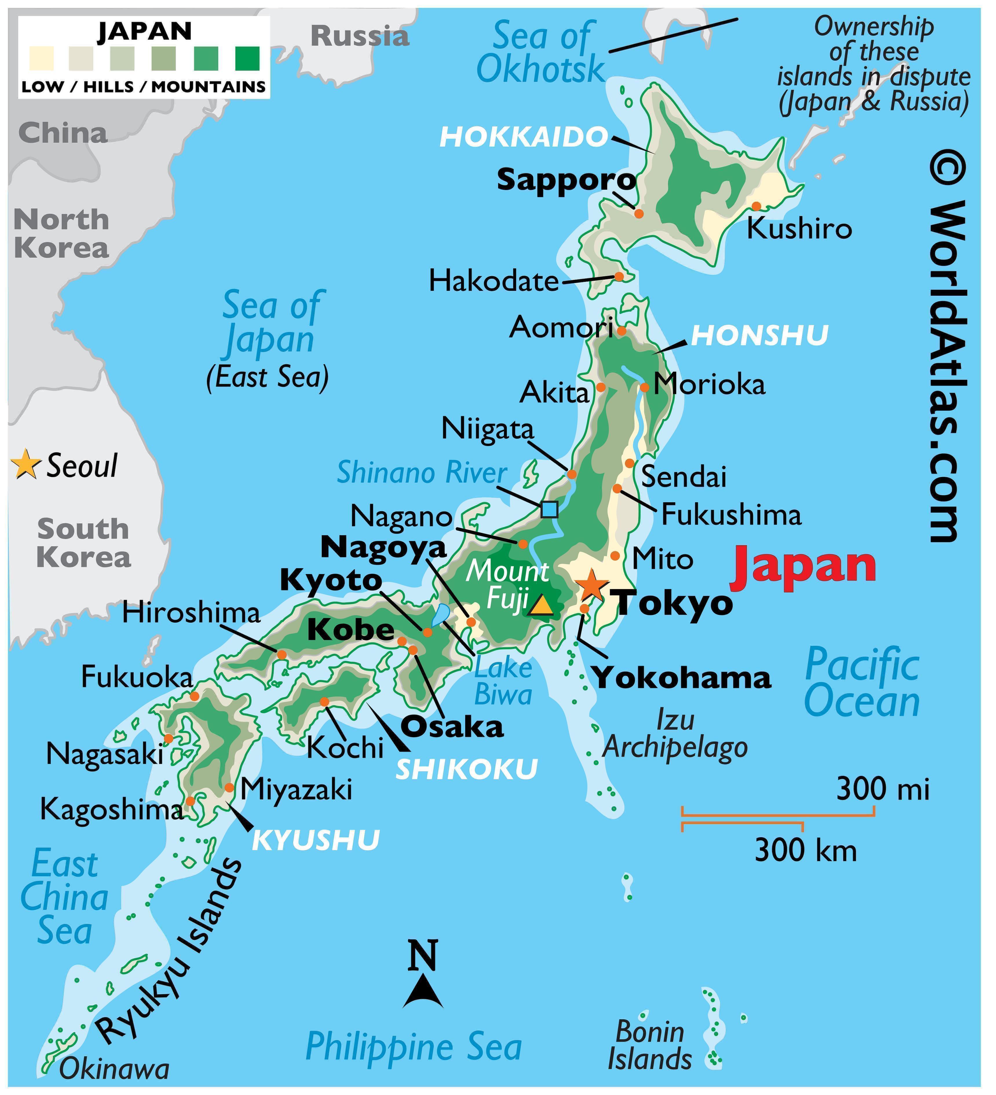
The foliage distribution strongly overlaps the mountainous areas which we described in the first of this series on Japan. To better appreciate the distribution of trees in Japan, the following illustrations will show the varieties and locations in the island group. This underscores the limited accessibility to manage the growth or to commercially harvest the wood.
The distribution of trees is approximately 40% deciduous and 60% coniferous and evergreen.This graphic is from “Forest and Forestry of Japan Textbook to Learn about Forests” . The Japan Forestry Association, “Forest zone of Japan”. Note our visited area is characterized as warmer temperature vegetation.
For more information on plants seen on this trip, please visit the Everglades Ark Epicollect database. to see more native trees and plants in seen on this visit. See observations numbers 422 to 434.
Reforestation:
There is a strong response to the tree management in today’s Japan. The forests of Japan rank third in the world for percentage of forest covered land. Modern management techniques including diversification of species are being applied and the use of local lumber is increasing.
Japan is now making a concerted effort to reforest and rewild their woodlands. Although this is a public works project and is government sponsored/funded it depends on community part time and volunteer workforce. It includes incremental reforestation using a variant of the Montreal process. This successful process has been widely applied in many locations around the world. The dedication and discipline of the people of Japan have made this do-it-yourself (DIY) project an example that could be followed here in Florida.
CONCLUSION
Forests continue to play an important part in Japan both spiritually and economically. Hopefully we can learn that over deforestation and questionable management can result in unintended consequences. The reversal of the untoward results can be costly, labor intensive and time consuming.
Next
In our next posting we will explore the productive gardens as farms in Japan. Later we will see the classic formal gardens
HERE ARESUGGESTED TOPICS FOR the discussion board
Where does the art of bonsai fit into Japanese culture?
How would you manage the woodlands of Japan?
What can we learn from the Japanese woodland management experiences?
How can we use the Florida Master Naturalist program to encourage woodlands management in our own neighborhoods?
If you have visited or live in Japan please add to this description.
Is Japan competitive with the world in lumber production?
The cultural changes of Japan are fascinating and profound. Journey with me and see how they have significantly influenced gardening on Honshu and all art in Japan. This posting is a generalized recapitulation of the history. It will help you follow the cultural forces as they change through time. Powerful characters in that history built these gardens and structures. We will look for the demonstration of these influences by interpreting the evolving style and content of their gardens.
We will look at three types of gardens which were made and modified over the last thousand years. I have selected Japanese history to follow the gardens. All of the gardens were made with special intention. In Japan there are three identifiable types of gardens; wilderness, production and formal (classical). These will be individually discussed in the posts to follow.
Early Development:
Fig 1. Early development. Expansion of native culture.
Shinto:
Shinto shrine with Tori gate, walking path, natural surrounding, and effigies representing important elements
Shinto is an ancient veneration based faith. It is native to Japan. It may have originated ~300 BCE. It is not a true religion. It attributes veneration to spiritual Kami; avatars of people, objects and forces in natural settings. The Shinto shrine is simple and rustic. It has specific elements and design style emphasizing nature. This is the earliest referenced form of Japanese gardens. The natural elements and symbolic representations in design are in nearly all subsequent classical Japanese gardens.
Buddhism:
Buddhism is a philosophic, faith based life style. It originated in India and came to Japan ~400 AD. It emphasizes simplicity, restrained behavior, self awakening, and reincarnation using meditation. There are many forms of Buddhism. Zen Buddhism is a Samurai adaptation of one of the extant Buddhist sects. It is more severe in imaging and its gardens are characterized by the use of stones, gravel and sand. The arrangement is designed for stationary meditation not for walking. This form of faith acknowledges the concept of limitations. The gardens encourage transcendence of the limitations of the objects.
Entrance gate to Buddhist monastery / garden
IMPERIALISM:
Walking path in a large and complex Kyoto Imperial garden. It includes Shinto elements of water, bridge, trees and shrubs, lanterns and other Kami references.
The emperors of Japan have a long and troubled history. They date back to 1000 BC well before written history. Imperial power has risen and fallen at lease three times in recorded history. In the last period, Imperial power did not return until after the second visit of Commodore Matthew Perry. He was sent by the US president to force the trade. Japanese nationalists precipitated the overthrow of the Shogun and reestablish the power position of the Emperor.
Samurai: CODE
Samurai warriors had a moral code of ethics and behavior. Their training started in childhood. It focused not only in strength but also intelligence. When they were not fighting or training their combat skills they practiced self reflection, studied philosophy, literature, and the arts. They showed discipline, frugality, kindness, honesty, personal duty & honor, athletics, military skills, military strategies and political savvy. Ultimately they were trained to be fearless in battle. They were rewarded with currency, land and promotion.
The samurai developed a complex hierarchal order. The shogun was the highest rank of military commander. The feudal land lords were called daimyo. The shogun and his samurai provided military protection to the emperor and the daimyo. Through aggressive civil warfare attrition, one Shogun eventually dominated. This resulted in the end of civil strife, a unified Japan and peace which lasted for 200 years. In total, samurai directed an inalienable influence for 600 years.
The White Castle built buy the samurai Shogun
Politics and civil war:
Two Samurai armies fighting for opposing Shogun who seek domination of territory and power. (Source Anonymous)
The four current and historic Japanese capital cities are on Honshu. Each has a palace with gardens built for an emperor. These palatial gardens were made for the royal entourage for pleasurable encounters. They were used for meetings, entertainment, and celebrations for those with imperial access. In private, the emperor entertained his friends and families, concubines and eunuchs and his other supporters. They were used for and socialization, fun, intrigues, scheming, and planning. They had outer buildings and walkways. There were surrounding walls and moats with defensive designs. A class of defensive warriors was encouraged to defend the high culture class. These men called samurai were dedicated and highly trained. They were better than the ancient Greek Spartans .
Mid development:
Fig. 2. Mid development. Philosophic and power structure development.
The Shoguns were highly successful leaders of the Samurai warrior class. Regional Shoguns built castles with associated buildings as well as gardens. These were strategically placed for conflict management and defense. Daimyo and Samurai also built traditional gardens because they had land and power to pay and support them. These private gardens were used as retreats for meditation and rest.
Late Development:
Fig 3. Late development. Japan followed a path from feudalism to world conflict and destruction.
During this period political pressure reduced support for some and increased support for other gardens. During the 1600-1850 (Eco) period Buddhism was controlled by the shogun. During the 1886 -1912 (Meiji) period the government forced a separation of Shinto from Buddhism. Buddhism was persecuted because it was considered a foreign influence. State money was no longer directed to the massive and expansive Buddhist monasteries and gardens. They deteriorated in structure and appearance. Shinto increased in importance and along with Confucian thoughts were strongly supported by the State. This accomplished four valued behaviors. It reduced the power of a passive Buddhist ideology. It reinforced commitment to Japanese nationalism. It forced discipline, militarism and ethnic superiority. This also supported naturalistic idealism and devotion to the Emperor, the State and ancestral heritage. The samurai were outlawed. The military continued the defensive and offensive duties and many of the ethics of the samurai. The leadership pursued fanatic militarism and ultra-nationalism. To capitalize on the gains of WW I and to compete with the western powers, in 1931 all resources of Japan were committed to expansion through “total war”.
Continuing Development:
Fig 3. Continuing development. Global interaction and Interdependence
The sequela of the bombing of Japan during World War II, particularly in cities like Tokyo, Hiroshima, and Nagasaki was devastation. The death toll was enormous. Among cultural artifacts, traditional Japanese gardens were too, heavily damaged or completely destroyed as a result of the conflict. There is insufficient data for a true count. Hundreds or perhaps thousands of national treasured gardens were lost.
Through military force, the USA substantially altered the Japanese culture early by gunboat and later by atomic bomb diplomacy. The first time was opened the borders to international trade and introduction of advanced technology. The second opportunity opened Japan to multilateral, international, equilateral negotiation and trade without warfare.
This leveling of the field has allowed the Japanese people to cooperate with other nations and peoples. They assimilated and develop new ideas without loosing their identity. They now share their culture with others. TheNamba Park is an excellent example of post-modern architecture and garden blended into the urban center of Osaka.
Conclusion
Many factors influenced the Japanese gardens: The Shinto veneration set the basics of the Japanese garden. Once established, the Samurai character and Shinto/Buddhist beliefs pervaded through the culture. My interpretation of the gardens emotes a display of discipline, unwavering moral values, intelligence, honor, and duty. The people of Japan have demonstrated continued adaptablity. The gardens of tomorrow will reflect the constants and the changes.
Period, era and influence and characteristics summarizing the progress of Japanese gardens
Topics for your discussion on the discussion board
Have we answered the question posed in the previous posting? “Can some value in Japanese ethnographic field work be extracted from study of the iconography of Japanese gardens ?” How do you see the evolving relationship of Shinto, Buddhist and Samurai behavior? Please show and interpret examples of your local gardens that reflect the thinking, philosophies or values of your community.
If you have expert knowledge in Japanese gardens please share your thoughts or images in the discussion board. This will help us all learn more.
If you want to enter into a dialogue please use the discussion board and engage in group participation.
NEXT
In our next posting we will explore the three forms of gardens in Japan.
If you wish to express your ideas please use the comment box below.
If you wish to be notified of future postings please enter your email address and click on Subscribe.
Recommendations for film lovers:
Yojimbo by the award winning director Akira Kurosawa
Age of Samurai: Battle for Japan, A period docudrama currently on Netflix directed by Stephen Scott,
Last Samurai Standing a docudrama currently on Netflix staring Tom Cruise, directed by Michihito Fujii
The Last Samurai, A period docudrama on Netflix directed by Edward Zwick,
This is the first of a series of postings on gardens in Japan. It is the result of a three-week, September visit in the central area of the island of Honshu, Japan. It focused in the area between Kyoto and Tokyo (Fig 1). This is called the Golden Route. These are my interpretations of observations of this on-site visit supplemented by a review of some of the relevant literature. The gardens are a small sample of complex art forms generated by the Japanese over the past 1000 years. It involves a combination of art, history, philosophy, politics, wealth, power struggles, and a dynamically adaptive way of life. Approximately 15 sites were visited in and around the cities of Osaka, Kyoto, Matsumoto, Nara and Tokyo. From my American and European experiences I found their visual impact emotively stunning. Much of the area seen reminded me of my home in Florida. It was so familiar but so foreign. This led me to ponder the contrasts and parallels of these eastern and western cultures. I was full of questions. I wanted to know what do the Japanese want us to think when we see their gardens ? What do the gardens tell us? What can we learn from the gardens?
There are many important factors that influence the gardens that include geology, geography, ecology, philosophy, and history. Surprisingly, there are similarities and parallels between Japan and America. Follow along with the Everglades Ark for a fascinating exploration.
Geology:
Japan is series of islands that act as a geologic barrier to the pressures of the Pacific Ocean. It is part of the “ring of fire” generated by four massive tectonic plates. Seventy five percent of the islands are mountainous that include volcanoes. It is subjected to the severest forces of nature including, earthquakes, typhoons, tsunamis, tropical storms, and lava eruptions. See Fig 1.
Fig 1. Honshu, Japan, geology and the area of travel
Fig 2. Japanese islands overlying US eastern seaboard
Geography:
The three larger islands of Japan lie, latitudinally, in a position similar to the eastern seaboard of the United States. If overlaped on the USA, they could cover an area extending from Main to Florida and from the Appalachian mountains to the Atlantic Ocean. The Pacific typhoons are like the Atlantic hurricanes on the coast of North America. They are generated by the warm air and water energy in the western Pacific Ocean. They follow the Kuroshio current that runs northerly along Japan’s eastern coast. This is equivalent to the African Easterly Jet and the Gulf Streams. The water and air streams move northerly along both east coasts east coast.
The weathering of the mountains of both areas have similar erosive effects. Tropical storms slam into the mountains causing erosion of the weathered rocks which is washed downward to the sea. Gravel, sand, and mud flow down their eastern slopes to cover the bedrock topography of the east coasts. This action creates broad deep coastal planes of fertile sedimentary soils ideal for plant growth to flourish. In Japan there is an additional source of nutrients to enrich soil. These are the volcanic effluents which additionally characterize the mineralogy of the land. See Fig 2.
Fig 3. Earth’s most densely populated city seen from the Tokyo tower looks the same in all directions.
Population:
The population of 122 million in Japan is nearly equal to the east coast of the US. The most populous portion of these islands lies in an area similar to the US Carolinas . The Tokyo central part of the city (Fig 3) has 15 million where the population density is 6,363/km2 (16,480/sq mi). The metropolitan area has 41 million where the density is 3,000/km2 (7,900/sq mi). The buildings are generally less than 60 years old because of the effects of American bombing in WW II. The construction materials are mostly steel reinforced concrete and glass; not wood. This image begs the question; Where are the gardens? This series of postings shows how I tried to attain understanding.
WHAT IS NEXT:
In postings still to follow, we will discuss interactions of all these factors and the probable anthropologic significance of Japanese gardens. Additionally, we will confront a question. Can some part of Japanese ethnographic field work be extracted from study of the iconography of Japanese gardens ?
SUMMARY:
The soil, water and weather are fundamental to the materials and design of Japanese gardens. The area visited was subtropical. During the three weeks of the trip, the midday temperature averaged 950 F and the humidity was nearly 90%. The daytime sky was mostly cloudless. In the month of travel, the island experienced two typhoons. It was just like home in Florida! But it wasn’t.
If you wish to express your ideas please use the comment area below.
If you want to enter into a dialogue please use the discussion board and follow the group participation.
If you wish to be notified of future postings please enter your email and click on Subscribe.
The Ark is on its way to Honshu, the main island of Japan. The travel route is eastward from Florida. There will be a stopover in Germany for a few weeks. The most distant stop will be for three weeks in Japan. The return trip will be the reverse flight back to Germany and finally to Florida.
There are many items on the to do list that include visits to cultural and historic sights but also to ancient gardens, the wilderness around Mt Fuji and other mountain trails along the way. Major cities will include Tokyo and Kyoto. Many important sites will be missed however that leaves room for growth.
Japan has many geological features and meteorological characteristics similar to Florida. It should be interesting to compare and contrast the the two distant sights.
This is a follow-up publication on Stony Coral Tissue Loss Disease. It describes the findings in the coral reefs in the Cayman Islands during a week in mid April, 2024. The travel to the island was reasonably easy and the accommodations onboard the live-aboard cruise were good. The conditions of the reef life and tropical fish however was disheartening. We have a big problem.
The featured image was made from a view of the sunset from the port on Grand Cayman island. The sunset may be symbolic of the future diving in the Caribbean. I hope that there is a recovery in the future.
As reported in four previous posts (Death in Paradise), there is a continuance of even greater proportions seen during this trip. I reported on the findings on the reefs around Roatan Island off the coast of Honduras two years ago. The condition of the reefs showed considerable loss of the polyp life because of Stony Coral Tissue Loss Disease (SCTLD). It was quite extensive and showed nearly 70% loss of life. At night the coral showed a significant loss of fluorescence because of the large dead areas of coral polyps. During the day one could see the areas of exposed stony skeleton of the reef.
The reef at multiple sites of the Cayman Islands including Grand, Little and Brack, has been devastated by the disease. The population of the reef fish is also significantly diminished. I did not make a count of the fish or of the areas of dead coral. Because of the extent of the dead coral there was no reasonable way for me to make an accurate comparison. It was very distressing. With the option to make 20 dives I made only 12. There was nothing worthwhile to see. I would estimate more than 80% to 90% loss of polyp life.
In conversation with other experienced divers on board the ship they said that they saw similar conditions across many of the Caribbean islands from Bonaire to the Mayan coast. Generally, they were unaware of the cause of the polyp depletion but said that it looked the same as in the Caymans. The less experienced divers were unaware of the problem and were happy to be in the warm water (85.5 degrees F). There was still some interesting wildlife but is was very reduced when compared to the concentration I had seen as little as 5 years ago.
50% of central coral head is dead. All of the surrounding coral is dead.
Coral completely over run by SCTLD.
70% of brain coral is dead. Surrounding coral is lifeless.
nderwaterOther areas typical of the reefs showing the discruction of the polyps.
Lion fish (Invasive)
Caribbean Spiny Lobster (Panulirus argus) It was good to see a lobster but formerly there were dozens.
Rough file clam (Ctenoides scaber). Similar to the disco-clam seen in the Palau reefs.
There was still life in the Caribbean but it may be below the 100-foot depth accessible for divers and also for much of the live that requires light. The life forms that were readily apparent were mostly bottom feeding animals. Sponges and soft fans were still alive and did not seem to be affected by the SCTLD.
The effects upon the economy that are a result of reef polyp loss are not readily available, however, many of the recreational hospitality workers are questioning their future employment opportunities. I suspect that there may be some resistance in these businesses to make these issues more public.
There has been some publication of the research into the cause of the disease and it seems that researchers have identified an infection. “Results suggest that the bacterial community may be involved in SCTLD, but other members of the holobiont (i.e., viruses and Symbiodiniaceae) may contribute to lesion progression”.1,2
Vectors and process of viral action is not yet publicized 3. One should not expect a recommended solution for a cure until much further research will be done. I anticipate that it may take decades and that the reef corals will not survive at the current rate of disease progress. This has a direct impact on the southwest coast of Florida.
If you have observed the effects of SCTLD in other areas of the Caribbean or other places in the world please engage in the SCTLD dialogue in the discussion board.
References: Where 2. and 3. are specifically related to work done in Florida reefs.
This small body of water is in the Bonita Bay residential community in the city of Bonita Springs, Florida. It has been discussed in the first two parts of this presentation. It was artificially constructed as part of a larger hydraulic system intended to manage the surface water of the four-square mile community property. This submission focuses on the details that are the foundation of the recovery.
The feature image shows an alligator taking a closer look at the pond.
The soil:
The base soil type is Anclote and Immokalee Sand and is consistent with the slough which divides the east and west portions of the property. The pond area was a mesic depression prior to development of the property.
The water:
The pond is ground water sourced and linked to the surrounding ponds with underground conduits and to the slough by an above ground weir. This design maintains the water distribution level through a gravity driven cascading water flow. 5.5 million gallons of water is recirculated every day through a series of pumps and filters which supports the water level and provides grey water irrigation throughout the property. These pond hydrologic and geographic charts are from the Lee County Land and Water Survey.
Chart of water depth
Point of maximum depth.
Areas of submerged aquatic vegetation
Chart of bottom hardness
The chemistry:
The ponds are regularly sampled for chemistry and the specimens are sent to the State of Florida for analysis. Here are the results for pond #47 from our BBA Water Committee. The last chemical analysis report on this area was 1/23/2021. Note that the total phosphates and ortho phosphates are elevated above the acceptable standards.
Statement of Pond chemical analysis supplied by Bonita Bay Community Association:
Hydrology, Geology and Biology graphic summary
The microbiology:
A sample of surface pond water in a small area of surface growth these microscopic specemines were found.
Spyrogyra ?
Desmosdesmus maximus & Mesotaenium
Gastrotrichs
Euglenia ?
Nauplius larva of a cyclops copepod
Diatom
These microbiological organisms are normal. The most important finding was the absence of unwanted forms such as cane toad eggs, mosquito larvae, or invasive aquatic plants.
Statement of Pond Condition:
When surveyed on 04/10/2021, the water level was at 0.3 m (NAVD’88) for a water volume of 13,670 m3, a planar surface area of 7,130 m2 and a perimeter of 420 m. The mean depth of the pond was 1.9 m for a maximum depth of about 3.5 m in the central portion of this triangular pond. On 06/19/2021, the water was slightly brackish and hard with an adequate pH. The water column was thermally well mixed and the dissolved oxygen was about 6.9 ppm (adequate level) until about 1 m where a steady drop of dissolved oxygen occurred until it reached anoxia near the bottom (i.e., no dissolved oxygen). The sediment accumulation in this pond was moderately thick with 33% organic content. Based on the nutrients analyses, the pond was nutrients rich (eutrophic). The copper concentration was not determined in this pond. Although there are no standards for sucralose concentrations in the water, based on the range of sucralose concentration found at the BBCA ponds studied, pond 47 was found to have moderate levels of sucralose concentration which ties its nutrient loading to the use of reclaimed water. The pond was surrounded by lawns with some rooted vegetation near the edge of the water. Banks were also quite steep. There were some aquatic plants around the periphery of the pond with a higher density in the northeastern littoral zone which likely limited the nutrient loading into this pond.
Recommended Land management plan:
1. Sediment mapping: map the sediment including thickness and nutrient analysis by depth. 2. Dredging: Not currently necessary but depends on sediment map results. 3. Flocculation: Treat to mitigate nutrients in the water column and in the sediment. 4. Circulation: Not currently needed. 5. Aeration: Not currently needed. 6. Planting: Shoreline shows minor erosion. Verify plant recovery in 2025. 7. Shoreline restoration: Not currently needed 8. Restrict lawn fertilization of neighboring grass and ornamental trees. 9. Advocate reduction in lawn size and support native plant gardening.
The pond was significantly refurbished in 2020. The water level was reduced to 25% of filled. The soil was supplemented and recontoured to eliminate a steep drop at the water line that was the result of erosion. All house roof runoff was diverted by mandated gutters and downspouts. The downspouts were directed underground into the pond. The shores were remediated with contouring, installation of a soil retaining mesh and generous planting of aquatic vegetation at the new shoreline. The pond was allowed to refill naturally. Hurricane Ian, which occurred in September 2022, was a very destabilizing climatic event which significantly altered most of the ponds in Bonita Bay Community. Ten feet of sea water inundated lake #47. The height has returned to normal and the chemistry is slowly recovering. The selected soil stabilizing plant life surrounding the pond was thought to be lost but after two years is now slowly regrowing. The next State reported sampling will be done in 2025.
Summary:
The pond appears to be recovering well from the hurricane event two years ago. The foundation has been well preserved. I expect that the physiology of the ecosystem will stabilize at the levels near those reported in 2021. Sediment mapping is overdue considering the levels of nitrogen and phosphorus. There may be some improvement in the shoreline vegetative growth. It is remarkable that this totally artificial body of water provides so much to help to support all this diverse wildlife. The related sixty community ponds have responded equally well to similar care. This is an excellent example of cooperative natural growth and human intervention to produce a beautiful eutrophic environment.
If you wish to be notified of new posts enter your email and click on Subscribe.
If you wish to contribute to this subject please use the comment box.
Please feel free to participate in the discussion board. You may engage in a current discussion or start a new topic.
The plants of pond #47 are slowly recovering after hurricane Ian. This is part two of a three part series describing the slow recovery of the artificial pond that was created as part of a community wide system. Be sure to read part one of this series. The ten foot high storm surge from hurricane Ian brought seawater with its salt content and fish and other marine life. Because salt water is heavier than fresh water it sank to the bottom of the pond displacing a substantial portion of the fresh water. The ocean water is toxic to the fresh water species because it dehydrates the cells of salt intolerant plants and animals. This has been recovered by the inflow of fresh ground water and water filtered by community supplier. Now the water has a very low percentage of salt. My refractometric test for salinity tested on 5/1/2024 shows a near normal specific density of 1.002. We will discuss this in the next posting describing pond geochemistry.
The pond is surrounded by grassy lawns which are tended by the gardeners and home owners. At the water’s edge soil retaining mesh and plants have been added to prevent erosion. Most of these plants were thought to have been lost from toxic levels of salt. In the intervening two years they have begun to make a strong come back. They hold the soil, provide shelter for the marine animals and a feeding ground for the wading birds. Look at the previous post to see the birds feeding in grass and reed areas of the pond.
Pond plants
Net casting in pond to capture fish sample. This photo also shows round bright areas where Tilapia fish made nests
Soil retaining mesh submerged can be seen here. This was placed before the storm as part of the pond remediation.
Aquatic plant species used to reduce soil erosion.
Long view of pond looking from southeast to northwest.
Lawn, grass, Live Oak trees with marsh rushes and tubers surround the pond. They stabilize the soil and provide shelter and food as the basis of the ecosystem pyramid. It is only recently that the survivability of this plants was confirmed. Presence of these plants supports the concept of corner stone species. Without these plants the insects would not lay eggs. The fish would not feed on the insect larvae. The birds would not feed on the fish. This is further reflection of the eutrophic quality of the pond system.
Perhaps you have seen similar recoveries. Recall the experiences of the recovery of the Fulda river in Germany. Let’s hear about your experience! If you wish to contribute to the discussion please use the comment box.
The third of the three related postings on this pond will appear soon. It will describe the hydrochemistry and the micro aquatic inhabitants. Be sure to subscribe to follow along.
Also, feel free to use the discussion board to participate in one of the ongoing discussions or to introduce a new topic.
If you wish to be informed of new postings, lease enter your email and click on subscribe.
#Pond recovery #ocean water #Lance leaf Arrowhead #Needle rush #Horsetail spike rush #cornerstone species #
This is a story of cooperation among people and wildlife in the Bonita Bay community. This description is divided into three postings including the macro biology, micro biology and geochemistry. Pond #47 is in my backyard. The freshwater pond was inundated by sea water to a depth of 10.3 feet above MSL. The flood was a climatic challenge to the entire four square mile community property including all 64 retention ponds. The good news is that recovery is well on the way to near normal conditions.
This first of three postings shows the macro biologic content of the pond. This small body of water is in the Bonita Bay residential community in the city of Bonita Springs, Florida. It was artificially constructed nearly 40 years ago as part of a larger hydraulic system intended to manage the surface water of the community property. The property is bounded by Spring Creek to the north, Imperial River to the south, Bonita Bay to the west and highway 41 to the east. There are five animal phyla represented here and they are all thriving. There are also four plant phyla.
The featured picture is one of hundreds of halloween pennant dragonflies that were so full of beautiful color. I had to share it with all of you.
Fish:
Net casting was done to collect fish samples and to check the varieties. It shows the net hitting the water, the clarity and depth, and the light-colored ring patterns in the water are spawning nests created by resident tilapia in the sandy bottom. Other techniques included fly casting and spin casting with artificial bait. Six fish species were caught from the Anchorage Pond #47. They included Mayan Cichlid, Blue Gill, Tilapia, Largemouth Bass, and Snook. Numerous minnows were seen but not caught. Neighbors who regularly fish the pond suggest that there are more Tilapia and fewer Snook since the Ian hurricane.
Blue gill on top, Tilapia (?) on bottom
Tilapia or Gulf Killfish (Non-Native)
Mayan Cichlid (Mayaheros urophthalmus) (invasive)
Snook (Centropomus undecimalis) (Non-native)
Reptiles:
Alligators and turtles live easily in the pond. The alligator population is variable and although it usually has one. During mating season there were at least two. The turtle population is greater than the alligators and from observation there are always at least four swimming near the surface. During the day these reptiles and crawl out of the ponds to lie on the banks.
Soft shell turtle (Apalone ferox)
Mating alligators
We’re done.
Marine Crustaceans:
One marine crustacean type was found. Three Blue crabs were found in the water along the shore. These were probably brought in by the hurricane.
Blue crab (female), (Callinectes sapidus)
Birds:
The number and species of wading birds is highly dependent upon season and weather. The birds may select those areas of the shoreline which are favorable to their food and which may be protected from predators by alligators. Here are some of the birds in the shore line vegetation hunting and eating with the alligator in their midst. The osprey was standing quietly watching from the close by tree. These birds were seen in March/April. The birds included Great Blue Herron, white and tricolored Herron, Ibis, ducks, Wood Stories, Anhinga, and Osprey.
Blue Herron
Anhinga caught a Mayan Cyclid
Great White Herron caught a minnow
Stork and Herron ignoring one another
Tricolor Herron searching for fish
Ibis in group of about twenty
American Osprey (Pandion haliaetus) waiting in tree
Insects:
The most obvious insect which could be attributed to the pond were standing or feeding on the pound shore line. The dragonflies observed were exclusively the Halloween Pennants and were in the hundreds. The White Peacock butterflies were flying about in small groups or pairs just on shore near the grass.
Halloween Pennant Dragonfly, (Celithemis eponina)
White Peacock butterfly (Anartia jatrophae)
The diversity of the wild life supports the eutrophic designation of the pond. Further examples of this follow in the next two presentations. They include the plants and the microflora with geochemistry. Be sure to see them too!
This story is similar to the previous posting on a river restoration project found in Fulda, Germany.
If you wish to receive notifications please enter your email and click on subscribe.
To participate in discussion use the comments block.
Everglades Ark has introduced an opportunity for people with similar interests to participate with one another by sharing ideas and information on topics related to the natural sciences. These may include a wide range of subjects from novel views or technology applications, beautiful experiences, unanswered questions, problem statements, research findings, educational application of natural science, citizen science projects, or simply to share your enthusiasm on a NatSci subject of your choice.
To participate: Go to discussion board on the opening page header bar and click on Discussion Board.Register and log-in to participate. Click on the linked topic of your choice and scroll down to the Leave a Reply box and write a Comment in the space available.
Because we are all colleagues, courtesy and respect for one another is expected. Although not required but to add value to statements, scientifically cited references with links would be appreciated. All comments are monitored.
This group of flower images were made from observations during the last February, March and April. This is the second of a series on wildflowers of SWFL. These images represent some of the flowers which were seen in three distinct environments: uplands, pine and saw palmetto flats and costal flats. There is some crossover of plants which may be seen in multiple environments. For organizational simplicity the images have been separated into two groups: those that grow better in moist soil areas are in the mesic group, those that grow better in dryer soils are listed in the dry mesic and xeric group.
The images which are used here for illustration show the beauty and diversity of the native plants. As a supplement to these images there is a spread sheet posted under PAGES of this site which lists the plant growing requirements. If you wish, this information may be used to assist in selection of plants which you could plant in your own SWFL community or home garden. The images are associated with a Fig #. That number is the data key number listed in the first (Left) column of the spread sheet. Use that number to correlate the image to the data.
The featured image is Figure 22. Pinebarren Goldenrod (Solidago fistulosa)
There are definitely fewer flowering plants in the dry group. These flowers are less flamboyant in color, shape and size. The dominant chromas are in the middle of the visible light spectrum, the hues are in the lighter range and the values are in the middle zones. Their growth in single plants tend to be in dense florets and panicles. As groups of plants they tend to be distributed in patches of the landscape. This may be related to their propagation frequently by seeding.
For the gardeners be sure to check out the supplement to these images on the spread sheet in the Pages post on this site titled findings/Wildflowers in SWFL
Here are images of flowers made from observations during the last three months. This is one of a series on native wildflowers of SWFL. These images represent some of the flowers which were seen in three distinct environments: uplands, pine and saw palmetto flats and costal flats. There is some crossover of plants which may be seen in multiple environments. For organizational simplicity the images have been separated into two groups: those that grow better in moist soil areas are in the mesic group. Those that grow better in dryer soils are listed in the xeric group.
The featured image is a Dixi Iris and a visiting Monarch butterfly
The images which are used here for illustration show the beauty and diversity of the native plants. As a supplement to these images is a spread sheet in the Pages post on this site titled findings/Wildflowers in SWFL. which lists the plant growing requirements. If you wish, this information may be used to assist in selection of plants which you could use in your own SWFL community or home garden. The images are associated with a Fig #. That number is the data key number listed in the first (left) column of the spread sheet. Use that number to correlate the image to the data.
There are definitely more flowering plants in the music group than the xeric. These flowers are flamboyant in color, shape and size. The dominant chromas are in the ends of the visible light spectrum, the hues are in the more saturated range, the values are in all zones and they may be multi-chromatic. Their growth as single plants tend to one bloom. As groups of plants they tend to be distributed in patches of the landscape. This may be related to their propagation frequently by rhizomes.
For the gardeners be sure to check out the excellent PAGES Excel spread sheet for the Wildflowers of SWFL data on these beautiful images.
If you like it click on LIKE!
If you wish to be notified of new postings please enter your email and click on subscribe
If you wish to contribute a comment of engage in a discussion please use the comments block.
Wilderness health determines human health. Public wilderness health programs are needed to reduce pressure on the remaining wildlife and all other resources. We need to continue to develop new technologies that assist in adaptation to environmental changes without over demanding the resources. This is an essay combining physics and biology.
The featured image is the sun in hand near sunset. Please also see the previous post on Sand, wind, Water and Fire.
Energy and the second law of thermodynamics:
You can’t beat physics. Probably the most delimiting aspect of physics is thermodynamics. Life anywhere needs energy to live and reproduce. Ultimately the sun is the source of all power on earth. Cells, especially in plants, import the free energy from the sun and use nutrients and a complex chain of chemical reactions and specialized compartments to sustain life. This metabolic reaction, organized by DNA, supports internal organization, self maintenance and reproduction. This is net organization. It is an alternative to an increasingly chaotic environment. The unusable waste and heat is the entropic result of metabolism. The growth and storage of resources in organic molecules of plants plus reproduction are the valuable byproducts of life. Animals use a similar but more consumptive process in exchange for mobility and associated behaviors.
This schematic shows cell biology and the level of organization as the process of life proceeds. The ending relative degree of order falls below the start point because the cell uses energy and nutrients to create order in the cell. The resulting byproducts of metabolism are less ordered than the cell and less than the start point.
As long as the sun shines, and plants and animals consume less energy than the storage rate, the system is static or even increases order by creating a surplus of stored energy. Contrarily, if consumption is greater than the storage rate, energy is depleted and entropy increases. Currently humans are over consumptive. We are depleting the reserve energy resources with the untoward results of increased chaos. To cope with this we have some biologic tools that might help us. They are Darwinian in concept. These include four characteristics; genetic variance, species differentiation by inheritance, selection by survival of the fittest, and time. These tools can be used to adapt to the changing future. They are simple but require overwhelming cooperation.
Here is what we could do to change biology:
Preserve the genetic diversity of life. It will save time when we need life forms with special properties. Use or develop plants and animals which are survivalists for specific purposes. It is easier to maintain tough species forms rather than vulnerable species. Live in communities which are located in geologically and climatically stable environments. These areas demand less energy for maintenance.
To counteract the probable climate change and chronic over-demand, we could re-engineer plants and animals. If the rate of genetic mutation of selected genomes is increased and we environmentally promote inheritance by natural selection we could reset the consumptive rate then we could stop increasing chaos and rebalance the physics. Enhance species could replace those which cannot adapt to change. Effectively we could counteract our hyper-consumptive behavior and re-terraform Earth to promote survival of the wilderness. This would select for our survival and aim for survival of all. There are other helpful green power resources that are currently employed but they require substantial energy to build and deploy.
This is all a fantasy and another reality will probably develop. The power of the sun and the adaptive capacity of DNA are the two things that will not change. Change will happen. it is difficult to predict and it is impossible to prevent. One must plan for survival and learn to go with the changes.
If you like it click on like.
If you wish to engage in a dialogue or provide further information use comments.
If you wish to receive notification of new posts please enter your email and click on subscribe.
While exploring six SW Florida preserved areas, the osprey, forest hawks, eagles, vultures, and owls were readily observed.
The featured image is a vulture. Bcause of its scavenging behavior most people don’t think of it as a raptor. I saw this one in full pursuit flight along the shoreline hummock of the Delnor Wiggins-pass park.
Most birds are generally carnivores. They prey on animals. As insectivores they feed on soft, small insects in their various developmental stages. Some feed on small non insect animals. Raptors however are exceptional, carnivorous predatory, hunters. Their target prey are other vertebrates. Powerful, skillful, and relentlessly hunting, they are specifically designed for their task. All raptors have hooked beaks, sharp talons, large acutely sensitive eyes and bodies aerodynamically designed for power and speed. Some specialize in aquatic species such as fish and others can feed on other birds and mammals which can be equal or greater than their size and weight.
EAGLES:
This mated pair of eagles were attending to their two chicks high in a slash pine nest. in the CREW preserve near the northern entrance
They are highly regarded by many people as exemplified by the US and Florida whose legislatures selected the Eagle as their State bird; athletic teams such as the falcons, eagles; hawks military equipment such as eagles, osprey, hawks, raptors.
American bald eagle
Mated pair of eagles
HAWK:
This hawk was readily available and posed perfectly perched on the branch. Its nest was high in a Cyprus tree about 150 meters away from my location. It is predictably found in the same area of corkscrew swamp in the spring. It hunts readily flying through the forested area where it is difficult to follow with a camera and difficult to separate from the foliage.
Red shouldered hawk (Buteo lineatus)
Hawk in Cyprus tree nest
Owl:
These two owls were such a surprise to find. The Great Horned owl was perched in a tree in the twilight and difficult to see however as it called out I wandered through the brush until I spotted it. it was quite dark. With auto focusing on the camera and photoshop used to brighten the exposure you can see what I found.
The screech owl was sitting in a bird box someone had thoughtfully placed along a trail. It was in full daylight that I saw its head in the opening of the shelter. As I moved side to side it watched me despite its nearly closes eyes.
Great Horned owl (Bubo virginianus)
Eastern Screech owl in nest box (Megascops asio)
These birds are always on the hunt for anything edible. They are opportunistic feeders on small animals and roadkill.
OSPREY:
One of my favorite birds, the osprey is endlessly fascinating to watch. This nest was in a high tree adjacent to the stream on the southern edge of the Estero Bay State Preserve. It was the only bird which I saw during the hours spent in the southern end of the preserve. It was working the river for fish. After it catches its prey, it sits in a tree with the catch pinned under one foot and munches through its meal
The osprey (Pandiion haliaetus) checking me out as it launches into its hunt for fish.
Fresh catch in its talons this osprey was flying on the way from the stream to its perch for a mid day lunch.
The raptors were the most constant species of birds found in all the sites. Perhaps this is because they are large, have a wide range territory for hunting, and were seasonally present during daylight hours. Regardless of these parameters they were thrilling to see. One could spend hours simply watching and studying their behavior. They inspire streams of contrary images; graceful but powerful, swift but accurate, savage but caring, camouflaged but beautiful, rapacious but selective. Hopefully we will capture videos of each of the species and present them later. We will spend more time on these birds in later posts.
If you like this post click on like.
If you wish to receive notification of new postings please enter your email address and click on subscribe.
We had an opportunity to explore three distinctly different areas in Southwest Florida. Discussion of these focused on upland systems that ranged from the interior of the Everglades to the Gulf of Mexico costal planes. The earlier posts described the geography and associated plants. Animals were also found. Here are some of the feathered vertebrate species: Avians. The animal classification will follow the previously posted bird Clades. The important lesson learned here is animals predate on each other and share the environment by mutual specialization. We will discuss the significance of this concept after we have a chance to see the animals. There are some general observations which may be time or seasonal related conditions. During exploration of the various locations the song birds were less frequently found in the flatwoods. Additionally, the waterfowl were never found in the pine or scrubby flatwoods. The raptors were found in all explored areas.
The featured image is a nesting American Bald Eagle (Haliaeetus leucocephalus) with chick. This very large nest is in a hardwood, upland Slash pine near a creek.
THE BIRDS:
There were three types of birds which I photographed. All of them are wonderous in their appearance, behavior, songs, and interactions with their surroundings. To really appreciate them you must go into the field, be patient, watch and listen. I could not photograph all I saw and this is not an encyclopedia of all that are present. The following posts are an opportunity to show what to expect to see when you are there. They will have more selected photographs of some of these magnificent animals.
Waterfowl:
Including: Spoonbill, Storks, Egret, Herron, Anhinga, Duck and others
This pair of Wood Storks were feeding deep in a swamp
Raptors:
Including: Hawk, Eagle, Falcon, Osprey, Owl and others
Red Shouldered Hawk has a nest in a hard wood upland portion of Corkscrew Swamp.
Songbirds:
Including: Cat bird, Cardinal, Blue Jay, Finch, Warbler and others.
Black and White Warbler eating insects found under Cyprus bark in Corkscrew Swamp
Some birds were out of range of the telephoto lens, some were covered by foliage, some were too fast or not in focus and some were not to be found because of seasonal changes. I did my best but we are not done. Further exploration will provide an opportunity to see more, enjoy the spectacle and photograph the events.